I watch the fields from the car window that seem to stretch without end. The land is a patchwork of dull browns and muted greens, lying bare and dormant. It is particularly silent, especially during winter when farmers are mostly away from the farmlands.
What I don’t yet know, looking out this window, is that beneath these endless plains lies another landscape that has been taking shape for millions of years.
The word that shapes what we see
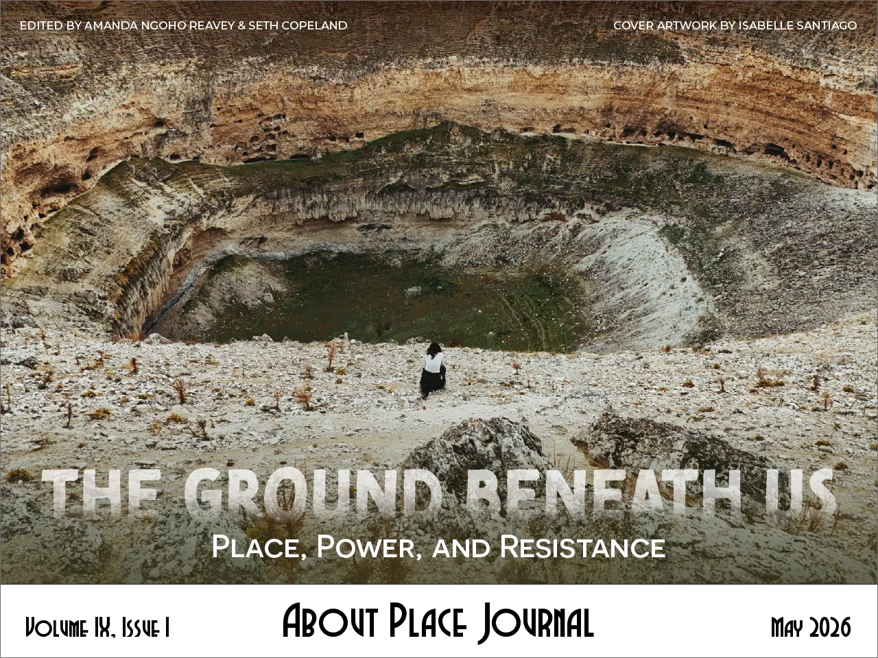
I flew from Dubai to Türkiye in pursuit of knowing, with my sight, touch, and own introspection, the unique circular openings in the Earth that Turkish papers call obruk.
There seems to be a dilemma with a term that has no precise English equivalent. The word obruk is easily translated as “sinkhole,” but it brings the image of disaster. The Obruk Plateau in the Central Anatolian region of Karapınar is far more nuanced than what reduced synonyms can describe it as. Obruks are among the oldest and most characteristic features of the landscape here—ancient karst formations produced over millennia that are inherently part of what this place is.
English does have geological terms for karst depressions: doline, uvala, polje, borrowed from the Slavic languages of the Dinaric karst, where European karst science was first systematized in the nineteenth century. But these remain specialist words. Sinkhole, the word mostly used and more easily understood, is built from a verb of loss.
Cognitive linguist George Lakoff argued that the metaphors embedded in language shape how we think about the concepts those words describe. If your default word for a karst void implies collapse, then karst voids are conveniently assumed as collapse.
I think about this as we drive through the plateau. Language is a kind of gravity. It pulls us toward certain understandings and away from others. Sinkhole visualizes a disaster; and once it is framed as a disaster, it then villainizes its nature.
After all, what was the nature of this land before we decided what it is now?
What exactly is the problem?
Karapınar is a town almost unknown beyond Türkiye. Yet it sits within a 2,747 km² land, roughly the size of Luxembourg, that holds more “sinkholes” than almost anywhere else on Earth. By 2021, researchers had counted nearly 700 large obruks in Konya region, where Karapınar sits, alongside roughly 1,850 smaller subsidence structures.
Fatih Arslan, journalist and editor-in-chief of Meke Agency, has been documenting the obruks of Karapınar for about ten years. Ten years are surely a long time but quite not enough for an intricate subject such as the obruk. We are driving across the plateau when I ask him what else has not been widely discussed about. He goes straight to the beginning.
“Many people believe sinkholes are caused by farmers pumping groundwater through wells. It can certainly be a contributing factor, but in my view, it is not the root cause. The Karapınar Obruk region has had obruks since pre-Christian times. Back then, there was no intensive agriculture here. That alone shows they existed long before modern groundwater use.”
Before flying here to Türkiye, I had a preconceived understanding of an obruk as an abrupt disturbance—similar to a landslide, storm, earthquake—that comes and devastates what it surrounds with. Yet, as Fatih reminds, many obruks on this plateau were formed from a process that began more than two and a half million years ago. Obruks have always been here as water worked through limestone, clayey limestone, and marls of the İnsuyu Formation. It was not particularly disastrous then.
This raises a question that the contemporary conversation about obruks tends to miss: If the land has always produced obruks, what exactly is the problem?
Fatih slows the car and pulls over.
The land beneath before it’s seen
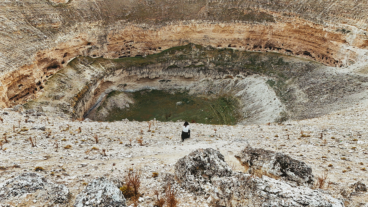
On a vast, seemingly endless, eerily silent plain, there is a sudden opening in the middle. As I approach it, it becomes bigger, wider, more like a delicate architecture.
“Look closer,” Fatih says. Cut into the interior walls of this obruk, into the shadowed sections, are caves with seemingly hand-hewn rooms carved directly into the rock face.
Çıralı Obruğu is a giant paleo-collapse obruk on the Obruk Plateau, a cenote-type formation roughly 440 meters across, its terraced limestone walls descending nearly a one hundred thirty meters to a floor that once held a lake. This obruk did not form simply from a collapse, as one might typically imagine. It was eroded from above and hollowed out from below by intense carbon dioxide rising from both the surface and the magmatic rock deep within the earth.
The cave dwellings visible along the crater walls represent a fundamentally different relationship to this landscape. It suggests generations of people who understood the obruk’s structural integrity and the ancient understanding of it as a place where the Earth’s depth is one more eccentric quality of a living land.
The modern framing of an obruk as land swallowed seems to be built from the selfish belief that flat land is productive land and any deviation from flatness, or particularly useful to human, is damage.
What keeps the ground up
Professor Fetullah Arık has spent thirty years studying what is happening beneath this plateau. He heads the Sinkhole Application and Research Centre at Konya Technical University and coauthored Türkiye’s first Sinkhole Fundamental Guide and Sinkhole Technical Guides published in 2023.
“Our underground water system is much like blood flowing through capillaries in the human body,” he says. “We have very little water circulating in the lower geographical region, which is why sinkholes form.”
The bedrock beneath Karapınar surfaced eight to eleven million years ago, when this basin contained a large inland lake. Its sediments are rich in carbonates; they contain limestone, dolomite, dolomitic limestone, clayey limestone, and marls, as well as evaporite minerals such as halite, gypsum, and anhydrite, which are soluble rocks. Arık explains that since then, water has moved through cracks and fractures in the soluble rocks, pressing into each crack it passes through, chemically expanding it, and transforming capillary cracks into passages, passages into chambers, and chambers into voids. As a result of these events, which continued for millions of years, the underground rocks have been transformed into hollow architecture.
The ground above stays level because the water below is holding it. Remove the water, and the ceiling has nothing keeping it in place. With continuous dissolution, both the voids expand and the thickness of the cap rock decreases. As a result, due to the widening of the voids and the thinning of the cap layer, the overburden above the void can no longer support its own weight and collapses.
Irrigation expanded across the basin from the 1960s onward, drawing from an aquifer that took millions of years to fill. Extraction rates have long outpaced recharge. In a closed basin, this imbalance is irreversible in any human timeframe: there is no upstream source to draw from, no lateral inflow to compensate. Meanwhile, annual precipitation across the region has declined measurably over recent decades, compressing what was already a semi-arid water budget. Arık calls the region “almost desert-like.”
This description that would have probably made no sense to the farmers who first sank their wells here two generations ago.
The surface is the last thing to know
The surface gives no sign of what is happening beneath it. This has become the human problem.
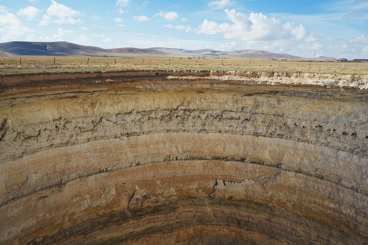
One evening it was level pasture. By morning, İnoba Obruğu had opened, a thirty-five-metre shaft dropping straight into the Earth, its walls stripped back to reveal the basin’s own sedimentary record in horizontal bands of cream and ochre and grey, each layer a different age, stacked in a sequence that took millions of years to accumulate and a single night to expose.
The literature calls it a cover-collapse obruk. The cavity had been forming in the bedrock far below for years, perhaps decades. The surface continued to hold, suspended above the void on a thin cohesive layer of soil until, one night, it gave way. The ground was not warning anyone.
Before 2000, new sinkholes formed in the Konya basin at a rate of roughly one every few years. Between 2000 and 2010, it was a few per year. After 2010, dozens per year. The geology is the same. The water withdrawal rate is different because the land is being asked for more.
To suffice more
Karapınar is a large district that leads Turkey in agricultural output. Farming here is passed from one generation to the next. The land feeds the town, funds the schools, fills the houses.
Caner Çorakçı is a 28-year-old farmer who fondly describes the land as “The bread, our mother and father. If we didn’t have a source of income from the land, the buildings, cars, and people you see here wouldn’t exist.”
He recalls that when he was a child, obruks did not appear across the landscape. “There was nothing like that. Our groundwater was quite sufficient.” Sufficient is a word that sticks to me. Can the land suffice the demands of human? Çorakçı admits himself: “The greater rise of a nation, the greater ambition of an individual or a farmer to earn more. Our citizens need more, more production. This requires more grain and more imports for our country, so we will plant even more and irrigate even more.”
More can never be relieved of itself. This is the oldest tension in agriculture, perhaps in human civilization itself.
The land has a nature. So do we. The land’s nature is geological, patient, indifferent to our calendars and our hunger. Ours is immediate, shaped by necessity and the simple fact that people need to eat and farmers need to survive. We are no greater than the land that feeds us, and yet we have spent generations behaving as though its limits were negotiable.
What this land can sustain
Perhaps it can be negotiable—in the sense that we listen more closely to what the land can sustain and meet it there. “Agricultural production in the Konya Closed Basin should be carried out according to the existing water resources,” Arık says.
“This means reducing the cultivation of water-intensive crops such as corn, sugar beet, and alfalfa, and shifting towards wheat, barley, and fruit trees. Proportionally reducing cattle farming, which consumes a lot of both nutrients and water, and encouraging small livestock farming will reduce water usage. Instead of random irrigation, it would be more rational to provide water only as needed by the plant.”
To ask what a land complements is to accept that the land has a nature prior to our intentions for it, and that our best agriculture is not the one that maximizes what we take but the one that remains legible to what was already here.
The depth of bread
Back in the car, the fields return. We really haven’t looked enough, I think to myself.
The bread comes from the surface: from the soil, the rain, the seed, the season. From everything visible and subject to human intention. The ground that makes all this possible comes from below, from limestone, from water moving through rock, from a landscape that was old before the first farmer turned the first soil on this plateau. The two have always shared the same Earth, but we tend to notice only what we stand on.
Çorakçı said the land is our mother and father.
And like many children, we have taken what was given without asking what it cost to give it. We learned the surface and called it the whole. We learned the yield and called it the land. We rarely wondered what was underneath—what had been invisibly sustaining everything we built our lives around long before we arrived to build them.